Aviation Weather - Principles
Whether preparing for a local flight or a long cross-country, flight-planning decisions based on aviation weather can dramatically affect the safety of the flight.
A solid understanding of aviation weather theory provides the tools necessary to understand the reports and forecasts obtained from a Flight Service Station aviation weather specialist and other aviation weather services.
The following pages are designed to help pilots acquire the background knowledge of aviation weather principles necessary to develop sound decision making skills relating to weather. It is important to note, however, that there is no substitute for experience.
Nature of the atmosphere
The atmosphere is a mixture of gases that surround the Earth. This blanket of gases provides protection from ultraviolet rays as well as supporting human, animal, and plant life on the planet. Nitrogen accounts for 78 percent of the gases that comprise the atmosphere, while oxygen makes up 21 percent. Argon, carbon dioxide, and traces of other gases make up the remaining 1 percent.
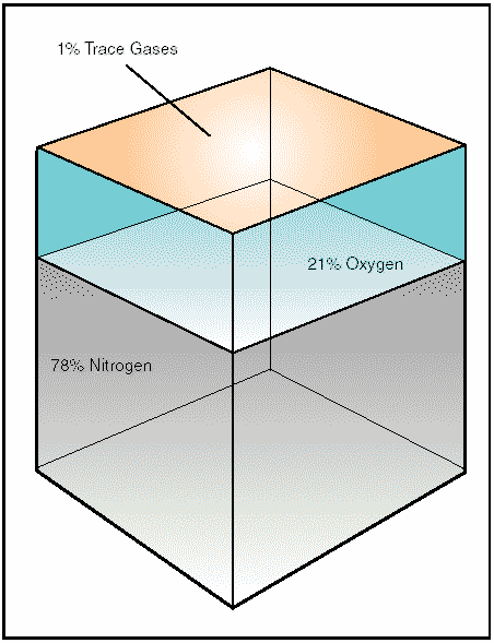
Figure 1: Composition of the atmosphere.
Within this envelope of gases, there are several recognizable layers of the atmosphere that are defined not only by altitude, but also by the specific characteristics of that level.
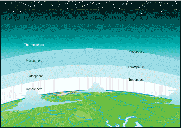
Figure 2: Layers of the atmosphere.
The first layer, known as the troposphere, extends from sea level up to 20,000 feet (6 km) over the northern and southern poles and up to 48,000 feet (14.5 km) over the equatorial regions. The vast majority of weather, clouds, storms, and temperature variances occur within this first layer of the atmosphere. Inside the troposphere, the temperature decreases at a rate of about 2°Celsius every 1,000 feet of altitude gain, and the pressure decreases at a rate of about 1 inch per 1,000 feet of altitude gain. At the top of the troposphere is a boundary known as the tropopause, which traps moisture, and the associated weather, in the troposphere. The altitude of the tropopause varies with latitude and with the season of the year; therefore, it takes on an elliptical shape, as opposed to round.
Location of the tropopause is important because it is commonly associated with the location of the jetstream and possible clear air turbulence.
The atmospheric level above the tropopause is the stratosphere, which extends from the tropopause to a height of about 160,000 feet (50 km). Little weather exists in this layer and the air remains stable. At the top of the stratosphere is another boundary known as the stratopause, which exists at approximately 160,000 feet. Directly above this is the mesosphere, which extends to the mesopause boundary at about 280,000 feet (85 km). The temperature in the mesosphere decreases rapidly with an increase in altitude and can be as cold as -90°C. The last layer of the atmosphere is the thermosphere. It starts above the mesosphere and gradually fades into outer space.
Oxygen and the human body
As discussed earlier, nitrogen and other trace gases make up 79 percent of the atmosphere, while the remaining 21 percent is life sustaining, atmospheric oxygen. At sea level, atmospheric pressure is great enough to support normal growth, activity, and life. At 18,000 feet, however, the partial pressure of oxygen is significantly reduced to the point that it adversely affects the normal activities and functioning of the human body. In fact, the reactions of the average person begin to be impaired at an altitude of about 10,000 feet and for some people as low as 5,000 feet.
The physiological reactions to oxygen deprivation are insidious and affect people in different ways. These symptoms range from mild disorientation to total incapacitation, depending on body tolerance and altitude.
By using supplemental oxygen or cabin pressurization systems, pilots can fly at higher altitudes and overcome the ill effects of oxygen deprivation.
Significance of atmospheric pressure
At sea level, the atmosphere exerts pressure on the Earth at a force of 14.7 pounds per square inch. This means a column of air 1-inch square, extending from the surface up to the upper atmospheric limit, weighs about 14.7 pounds.
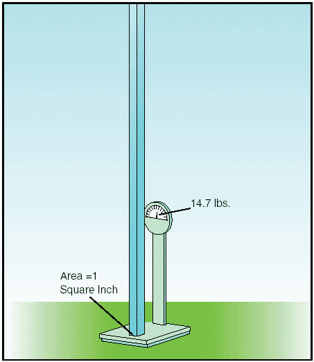
Figure 3: One square inch of atmosphere weighs approximately 14.7 pounds.
A person standing at sea level also experiences the pressure of the atmosphere; however, the pressure is not a downward force, but rather a force of pressure over the entire surface of the skin.
The actual pressure at a given place and time will differ with altitude, temperature, and density of the air. These conditions also affect aircraft performance, especially with regard to takeoff, rate of climb, and landings.
Measurement of atmospheric pressure
Atmospheric pressure is typically measured in inches of mercury (in. Hg.) by a mercurial barometer.
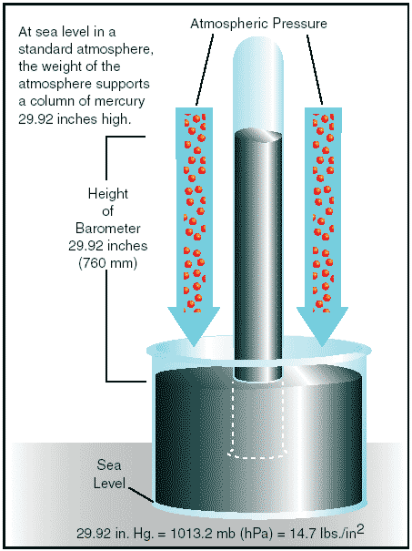
Figure 4: Mercurial barometer.
The barometer measures the height of a column of mercury inside a glass tube. A section of the mercury is exposed to the pressure of the atmosphere, which exerts a force on the mercury. An increase in pressure forces the mercury to rise inside the tube; as pressure drops, mercury drains out of the tube, decreasing the height of the column. This type of barometer is typically used in a lab or weather observation station, is not easily transported, and is a bit difficult to read.
An aneroid barometer is an alternative to a mercurial barometer; it is easier to read and transport.
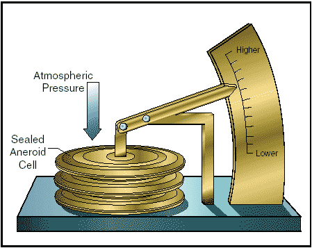
Figure 5: Aneroid barometer.
The aneroid barometer contains a closed vessel, called an aneroid cell, that contracts or expands with changes in pressure. The aneroid cell attaches to a pressure indicator with a mechanical linkage to provide pressure readings. The pressure sensing part of an aircraft altimeter is essentially an aneroid barometer. It is important to note that due to the linkage mechanism of an aneroid barometer, it is not as accurate as a mercurial barometer.
To provide a common reference for temperature and pressure the International Standard Atmosphere (ISA) has been established. These standard conditions are the basis for certain flight instruments and most airplane performance data. Standard sea level pressure is defined as 29.92 in. Hg. at 59°F (15°C). Atmospheric pressure is also reported in millibars, with 1 inch of mercury equaling approximately 34 millibars and standard sea level equaling 1013.2 millibars. Typical millibar pressure readings range from 950.0 to 1040.0 millibars. Constant pressure charts and hurricane pressure reports are written using millibars.
Since weather stations are located around the globe, all local barometric pressure readings are converted to a sea level pressure to provide a standard for records and reports. To achieve this, each station converts its barometric pressure by adding approximately 1 inch of mercury for every 1,000 feet of elevation gain. For example, a station at 5,000 feet above sea level, with a reading of 24.92 inches of mercury, reports a sea level pressure reading of 29.92 inches.
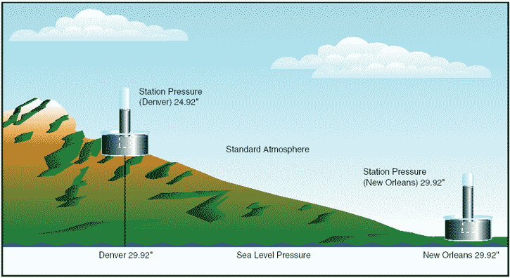
Figure 6: Station pressure is converted to, and reported in, sea level pressure.
Using common sea level pressure readings helps ensure aircraft altimeters are set correctly, based on the current pressure readings.
By tracking barometric pressure trends across a large area, weather forecasters can more accurately predict movement of pressure systems and the associated aviation weather. For example, tracking a pattern of rising pressure at a single weather station generally indicates the approach of fair weather. Conversely, decreasing or rapidly falling pressure usually indicates approaching bad weather and possibly, severe storms.
Effect of altitude on atmospheric pressure
As altitude increases, pressure diminishes, as the weight of the air column decreases. On average, with every 1,000 feet of altitude increase, the atmospheric pressure decreases 1 inch of mercury. This decrease in pressure (increase in density altitude) has a pronounced effect on aircraft performance.
Effect of altitude on flight
Altitude affects every aspect of flight from aircraft performance to human performance. At higher altitudes, with a decreased atmospheric pressure, takeoff and landing distances are increased, as are climb rates.
When an aircraft takes off, lift must be developed by the flow of air around the wings. If the air is thin, more speed is required to obtain enough lift for takeoff; therefore, the ground run is longer. An aircraft that requires a 1,000-foot ground run at sea level will require almost double that at an airport 5,000 feet above sea level.
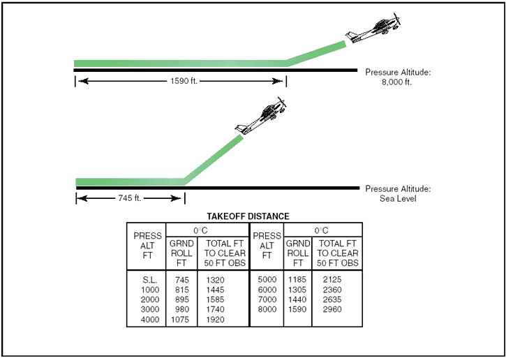
Figure 7: Takeoff distance increases with increased altitude.
It is also true that at higher altitudes, due to the decreased density of the air, aircraft engines and propellers are less efficient. This leads to reduced rates of climb and a greater ground run for obstacle clearance.
Effect of differences in air density
Differences in air density caused by changes in temperature result in changes in pressure. This, in turn, creates motion in the atmosphere, both vertically and horizontally, in the form of currents and wind. Motion in the atmosphere, combined with moisture, produces clouds and precipitation otherwise known as weather.
Wind
Pressure and temperature changes produce two kinds of motion in the atmosphere—vertical movement of ascending and descending currents, and horizontal movement in the form of wind. Both types of motion in the atmosphere are important as they affect the takeoff, landing, and cruise flight operations. More important, however, is that these motions in the atmosphere, otherwise called atmospheric circulation, cause weather changes.
The cause of atmospheric circulation
Atmospheric circulation is the movement of air around the surface of the Earth. It is caused by uneven heating of the Earth´s surface and upsets the equilibrium of the atmosphere, creating changes in air movement and atmospheric pressure. Because the Earth has a curved surface that rotates on a tilted axis while orbiting the sun, the equatorial regions of the Earth receive a greater amount of heat from the sun than the polar regions. The amount of sun that heats the Earth depends upon the time of day, time of year, and the latitude of the specific region. All of these factors affect the length of time and the angle at which sunlight strikes the surface.
In general circulation theory, areas of low pressure exist over the equatorial regions, and areas of high pressure exist over the polar regions due to a difference in temperature. Solar heating causes air to become less dense and rise in equatorial areas. The resulting low pressure allows the high-pressure air at the poles to flow along the planet´s surface toward the equator. As the warm air flows toward the poles, it cools, becoming more dense, and sinks back toward the surface.
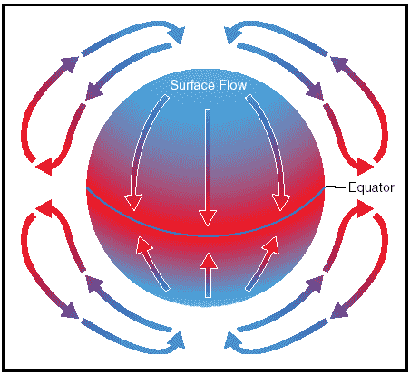
Figure 8: Circulation pattern in a static environment.
This pattern of air circulation is correct in theory; however, the circulation of air is modified by several forces, most importantly the rotation of the Earth.
The force created by the rotation of the Earth is known as Coriolis force. This force is not perceptible to us as we walk around because we move so slowly and travel relatively short distances compared to the size and rotation rate of the Earth. However, it does significantly affect bodies that move over great distances, such as an air mass or body of water. The Coriolis force deflects air to the right in the Northern Hemisphere, causing it to follow a curved path instead of a straight line. The amount of deflection differs depending on the latitude.
It is greatest at the poles, and diminishes to zero at the equator. The magnitude of Coriolis force also differs with the speed of the moving body—the faster the speed, the greater the deviation. In the Northern Hemisphere, the rotation of the Earth deflects moving air to the right and changes the general circulation pattern of the air.
The speed of the Earth´s rotation causes the general flow to break up into three distinct cells in each hemisphere.
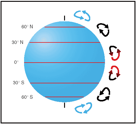
Figure 9: Three-cell circulation pattern due to the rotation of the Earth.
In the Northern Hemisphere, the warm air at the equator rises upward from the surface, travels northward, and is deflected eastward by the rotation of the Earth. By the time it has traveled one-third of the distance from the equator to the North Pole, it is no longer moving northward, but eastward.
This air cools and sinks in a belt-like area at about 30° latitude, creating an area of high pressure as it sinks toward the surface. Then it flows southward along the surface back toward the equator. Coriolis force bends the flow to the right, thus creating the northeasterly trade winds that prevail from 30° latitude to the equator. Similar forces create circulation cells that encircle the Earth between 30° and 60° latitude, and between 60° and the poles. This circulation pattern results in the prevailing westerly winds in the conterminous United States.
Circulation patterns are further complicated by seasonal changes, differences between the surfaces of continents and oceans, and other factors.
Frictional forces caused by the topography of the Earth´s surface modify the movement of the air in the atmosphere. Within 2,000 feet of the ground, the friction between the surface and the atmosphere slows the moving air. The wind is diverted from its path because the frictional force reduces the Coriolis force.
This is why the wind direction at the surface varies somewhat from the wind direction just a few thousand feet above the Earth.
Wind patterns
Air flows from areas of high pressure into those of low pressure because air always seeks out lower pressure.
In the Northern Hemisphere, this flow of air from areas of high to low pressure is deflected to the right; producing a clockwise circulation around an area of high pressure. This is also known as anti-cyclonic circulation. The opposite is true of low-pressure areas; the air flows toward a low and is deflected to create a counter-clockwise or cyclonic circulation.
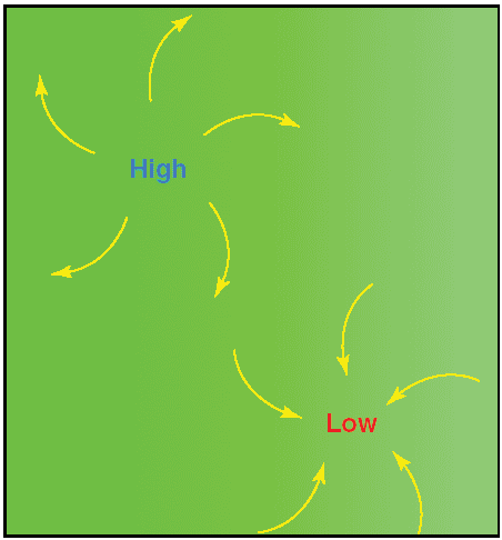
Figure 10: Circulation pattern about areas of high and low pressure.
High-pressure systems are generally areas of dry, stable, descending air. Good aviation weather is typically associated with high-pressure systems for this reason.
Conversely, air flows into a low-pressure area to replace rising air. This air tends to be unstable, and usually brings increasing cloudiness and precipitation.
Thus, bad aviation weather is commonly associated with areas of low pressure.
A good understanding of high- and low-pressure wind patterns can be of great help when planning a flight, because a pilot can take advantage of beneficial tailwinds.
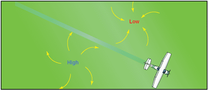
Figure 11: Favorable winds near a high-pressure system.
When planning a flight from west to east, favorable winds would be encountered along the northern side of a high-pressure system or the southern side of a low-pressure system. On the return flight, the most favorable winds would be along the southern side of the same high-pressure system or the northern side of a low-pressure system. An added advantage is a better understanding of what type of aviation weather to expect in a given area along a route of flight based on the prevailing areas of highs and lows.
The theory of circulation and wind patterns is accurate for large-scale atmospheric circulation; however, it does not take into account changes to the circulation on a local scale. Local conditions, geological features, and other anomalies can change the wind direction and speed close to the Earth´s surface.
Convective currents
Different surfaces radiate heat in varying amounts. Plowed ground, rocks, sand, and barren land give off a large amount of heat; water, trees, and other areas of vegetation tend to absorb and retain heat. The resulting uneven heating of the air creates small areas of local circulation called convective currents.
Convective currents cause the bumpy, turbulent air sometimes experienced when flying at lower altitudes during warmer weather. On a low altitude flight over varying surfaces, updrafts are likely to occur over pavement or barren places, and downdrafts often occur over water or expansive areas of vegetation like a group of trees. Typically, these turbulent conditions can be avoided by flying at higher altitudes, even above cumulus cloud layers.
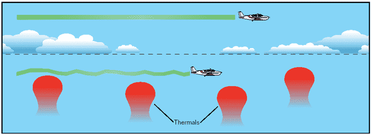
Figure 12: Convective turbulence avoidance.
Convective currents are particularly noticeable in areas with a landmass directly adjacent to a large body of water, such as an ocean, large lake, or other appreciable area of water. During the day, land heats faster than water, so the air over the land becomes warmer and less dense. It rises and is replaced by cooler, denser air flowing in from over the water. This causes an onshore wind, called a sea breeze. Conversely, at night land cools faster than water, as does the corresponding air.
In this case, the warmer air over the water rises and is replaced by the cooler, denser air from the land, creating an offshore wind called a land breeze. This reverses the local wind circulation pattern. Convective currents can occur anywhere there is an uneven heating of the Earth´s surface.
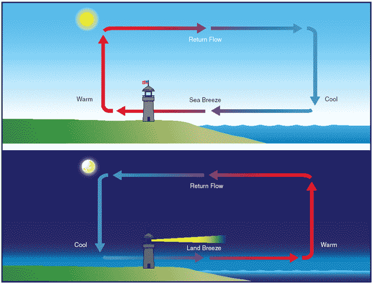
Figure 13: Sea breeze and land breeze wind circulation patterns.
Convection currents close to the ground can affect a pilot´s ability to control the aircraft. On final approach, for example, the rising air from terrain devoid of vegetation sometimes produces a ballooning effect that can cause a pilot to overshoot the intended landing spot. On the other hand, an approach over a large body of water or an area of thick vegetation tends to create a sinking effect that can cause an unwary pilot to land short of the intended landing spot.
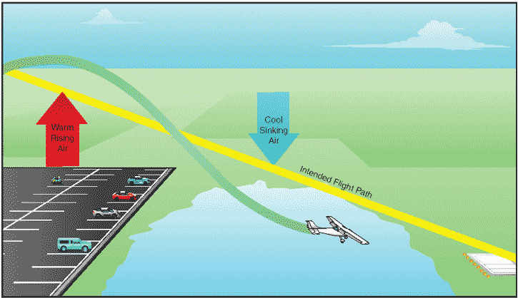
Figure 14: Currents generated by varying surface conditions.
Effect of obstructions on wind
Another atmospheric hazard exists that can create problems for pilots. Obstructions on the ground affect the flow of wind and can be an unseen danger. Ground topography and large buildings can break up the flow of the wind and create wind gusts that change rapidly in direction and speed. These obstructions range from manmade structures like hangars to large natural obstructions, such as mountains, bluffs, or canyons. It is especially important to be vigilant when flying in or out of airports that have large buildings or natural obstructions located near the runway.

Figure 15: Turbulence caused by manmade obstructions.
The intensity of the turbulence associated with ground obstructions depends on the size of the obstacle and the primary velocity of the wind. This can affect the takeoff and landing performance of any aircraft and can present a very serious hazard. During the landing phase of flight, an aircraft may “drop in†due to the turbulent air and be too low to clear obstacles during the approach.
This same condition is even more noticeable when flying in mountainous regions.
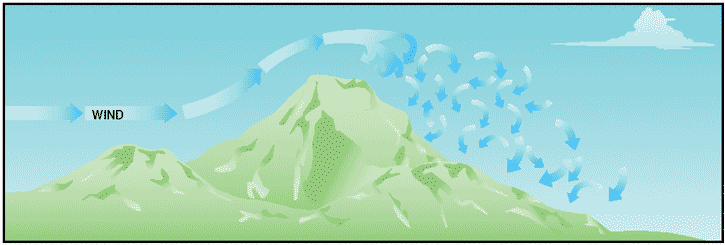
Figure 16: Turbulence encountered over and around mountainous regions.
While the wind flows smoothly up the windward side of the mountain and the upward currents help to carry an aircraft over the peak of the mountain, the wind on the leeward side does not act in a similar manner. As the air flows down the leeward side of the mountain, the air follows the contour of the terrain and is increasingly turbulent. This tends to push an aircraft into the side of a mountain. The stronger the wind, the greater the downward pressure and turbulence become.
Due to the effect terrain has on the wind in valleys or canyons, downdrafts can be severe. Thus, a prudent pilot is well advised to seek out a mountain qualified flight instructor and get a mountain checkout before conducting a flight in or near mountainous terrain.
Low-level wind shear
Wind shear is a sudden, drastic change in windspeed and/or direction over a very small area. Wind shear can subject an aircraft to violent updrafts and downdrafts as well as abrupt changes to the horizontal movement of the aircraft. While wind shear can occur at any altitude, low-level wind shear is especially hazardous due to the proximity of an aircraft to the ground.
Directional wind changes of 180° and speed changes of 50 knots or more are associated with low-level wind shear. Low-level wind shear is commonly associated with passing frontal systems, thunderstorms, and temperature inversions with strong upper level winds (greater than 25 knots).
Wind shear is dangerous to an aircraft for several reasons. The rapid changes in wind direction and velocity changes the wind´s relation to the aircraft disrupting the normal flight attitude and performance of the aircraft. During a wind shear situation, the effects can be subtle or very dramatic depending on windspeed and direction of change. For example, a tailwind that quickly changes to a headwind will cause an increase in airspeed and performance. Conversely, when a headwind changes to a tailwind, the airspeed will rapidly decrease and there will be a corresponding decrease in performance. In either case, a pilot must be prepared to react immediately to the changes to maintain control of the aircraft.
In general, the most severe type of low-level wind shear is associated with convective precipitation or rain from thunderstorms. One critical type of shear associated with convective precipitation is known as a microburst. A typical microburst occurs in a space of less than 1 mile horizontally and within 1,000 feet vertically. The lifespan of a microburst is about 15 minutes during which it can produce downdrafts of up to 6,000 feet per minute. It can also produce a hazardous wind direction change of 45 knots or more, in a matter of seconds. When encountered close to the ground, these excessive downdrafts and rapid changes in wind direction can produce a situation in which it is difficult to control the aircraft.
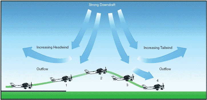
Figure 17: Effect of a microburst wind.
During an inadvertent takeoff into a microburst, the plane first experiences a performance-increasing headwind (#1), followed by performance-decreasing downdrafts (#2). Then the wind rapidly shears to a tailwind (#3), and can result in terrain impact or flight dangerously close to the ground (#4).
Microbursts are often difficult to detect because they occur in a relatively confined area. In an effort to warn pilots of low-level wind shear, alert systems have been installed at several airports around the country. A series of anemometers, placed around the airport, form a net to detect changes in windspeeds. When windspeeds differ by more than 15 knots, a warning for wind shear is given to pilots. This system is known as the low-level wind shear alert system, or LLWAS.
It is important to remember that wind shear can affect any flight and any pilot at any altitude. While wind shear may be reported, it often remains undetected and is a silent danger to aviation. Always be alert to the possibility of wind shear, especially when flying in and around thunderstorms and frontal systems.
Wind and pressure representation on surface weather maps
Surface weather maps provide information about fronts, areas of high and low pressure, and surface winds and pressures for each station. This type of weather map allows pilots to see the locations of fronts and pressure systems, but more importantly, it depicts the wind and pressure at the surface for each location.
For more information on surface analysis and weather depiction charts see the page on aviation weather reporting .
Wind conditions are reported by an arrow attached to the station location circle.
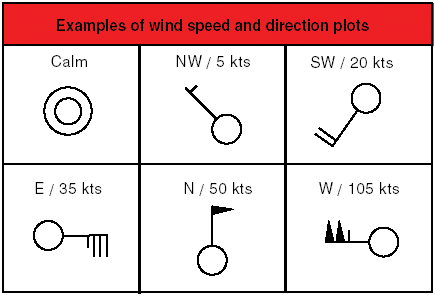
Figure 18: Depiction of winds on a surface weather chart.
The station circle represents the head of the arrow, with the arrow pointing in the direction from which the wind is blowing. Winds are described by the direction from which they blow, thus a northwest wind means that the wind is blowing from the northwest toward the southeast. The speed of the wind is depicted by barbs or pennants placed on the wind line. Each barb represents a speed of 10 knots, while half a barb is equal to 5 knots and a pennant is equal to 50 knots.
The pressure for each station is recorded on the weather chart and is shown in millibars. Isobars are lines drawn on the chart to depict areas of equal pressure. These lines result in a pattern that reveals the pressure gradient or change in pressure over distance.
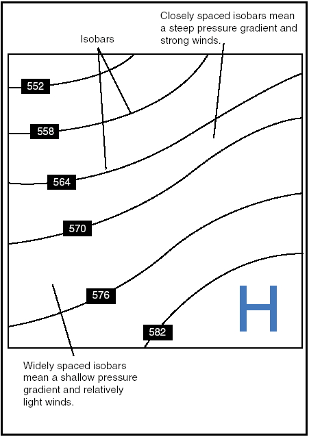
Figure 19: Isobars reveal the pressure gradient of an area of high- or low-pressure areas.
Isobars are similar to contour lines on a topographic map that indicate terrain altitudes and slope steepness. For example, isobars that are closely spaced indicate a steep wind gradient and strong winds prevail. Shallow gradients, on the other hand, are represented by isobars that are spaced far apart, and are indicative of light winds. Isobars help identify low- and high-pressure systems as well as the location of ridges, troughs, and cols. A high is an area of high pressure surrounded by lower pressure; a low is an area of low pressure surrounded by higher pressure. A ridge is an elongated area of high pressure, and a trough is an elongated area of low pressure. A col is the intersection between a ridge and a trough, or an area of neutrality between two highs or two lows.
Isobars furnish valuable information about winds in the first few thousand feet above the surface. Close to the ground, wind direction is modified by the surface and windspeed decreases due to friction with the surface. At levels 2,000 to 3,000 feet above the surface, however, the speed is greater and the direction becomes more parallel to the isobars. Therefore, the surface winds are shown on the weather map as well as the winds at a slightly higher altitude.
Generally, the wind 2,000 feet above the ground will be 20° to 40° to the right of surface winds, and the windspeed will be greater. The change of wind direction is greatest over rough terrain and least over flat surfaces, such as open water. In the absence of winds aloft information, this rule of thumb allows for a rough estimate of the wind conditions a few thousand feet above the surface.
Atmospheric stability
The stability of the atmosphere depends on its ability to resist vertical motion. A stable atmosphere makes vertical movement difficult, and small vertical disturbances dampen out and disappear. In an unstable atmosphere, small vertical air movements tend to become larger, resulting in turbulent airflow and convective activity. Instability can lead to significant turbulence, extensive vertical clouds, and severe weather.
Rising air expands and cools due to the decrease in air pressure as altitude increases. The opposite is true of descending air; as atmospheric pressure increases, the temperature of descending air increases as it is compressed. Adiabatic heating, or adiabatic cooling, are the terms used to describe this temperature change.
The adiabatic process takes place in all upward and downward moving air. When air rises into an area of lower pressure, it expands to a larger volume. As the molecules of air expand, the temperature of the air lowers. As a result, when a parcel of air rises, pressure decreases, volume increases, and temperature decreases. When air descends, the opposite is true. The rate at which temperature decreases with an increase in altitude is referred to as its lapse rate. As air ascends through the atmosphere, the average rate of temperature change is 2°C (3.5°F) per 1,000 feet.
Since water vapor is lighter than air, moisture decreases air density, causing it to rise. Conversely, as moisture decreases, air becomes denser and tends to sink. Since moist air cools at a slower rate, it is generally less stable than dry air since the moist air must rise higher before its temperature cools to that of the surrounding air. The dry adiabatic lapse rate (unsaturated air) is 3°C (5.4°F) per 1,000 feet. The moist adiabatic lapse rate varies from 1.1°C to 2.8°C (2°F to 5°F) per 1,000 feet.
The combination of moisture and temperature determine the stability of the air and the resulting weather. Cool, dry air is very stable and resists vertical movement, which leads to good and generally clear weather. The greatest instability occurs when the air is moist and warm, as it is in the tropical regions in the summer. Typically, thunderstorms appear on a daily basis in these regions due to the instability of the surrounding air.
Inversion
As air rises and expands in the atmosphere, the temperature decreases. There is an atmospheric anomaly that can occur, however, that changes this typical pattern of atmospheric behavior. When the temperature of the air rises with altitude, a temperature inversion exists. Inversion layers are commonly shallow layers of smooth, stable air close to the ground.
The temperature of the air increases with altitude to a certain point, which is the top of the inversion. The air at the top of the layer acts as a lid, keeping weather and pollutants trapped below. If the relative humidity of the air is high, it can contribute to the formation of clouds, fog, haze, or smoke, resulting in diminished visibility in the inversion layer.
Surface based temperature inversions occur on clear, cool nights when the air close to the ground is cooled by the lowering temperature of the ground. The air within a few hundred feet of the surface becomes cooler than the air above it. Frontal inversions occur when warm air spreads over a layer of cooler air, or cooler air is forced under a layer of warmer air.
Moisture and temperature
The atmosphere, by nature, contains moisture in the form of water vapor. The amount of moisture present in the atmosphere is dependent upon the temperature of the air. Every 20°F increase in temperature doubles the amount of moisture the air can hold. Conversely, a decrease of 20°F cuts the capacity in half.
Water is present in the atmosphere in three states: liquid, solid, and gaseous. All three forms can readily change to another, and all are present within the temperature ranges of the atmosphere. As water changes from one state to another, an exchange of heat takes place. These changes occur through the processes of evaporation, sublimation, condensation, deposition, melting, or freezing. However, water vapor is added into the atmosphere only by the processes of evaporation and sublimation.
Evaporation is the changing of liquid water to water vapor. As water vapor forms, it absorbs heat from the nearest available source. This heat exchange is known as the latent heat of evaporation. A good example of this is when the body´s perspiration evaporates. The net effect is a cooling sensation as heat is extracted from the body. Similarly, sublimation is the changing of ice directly to water vapor, completely bypassing the liquid stage. Though dry ice is not made of water, but rather carbon dioxide, it demonstrates the principle of sublimation, when a solid turns directly into vapor.
Relative humidity
Humidity refers to the amount of water vapor present in the atmosphere at a given time. Relative humidity is the actual amount of moisture in the air compared to the total amount of moisture the air could hold at that temperature. For example, if the current relative humidity is 65 percent, the air is holding 65 percent of the total amount of moisture that it is capable of holding at that temperature and pressure. While much of the western United States rarely sees days of high humidity, relative humidity readings of 75 to 90 percent are not uncommon in the southern United States during warmer months.
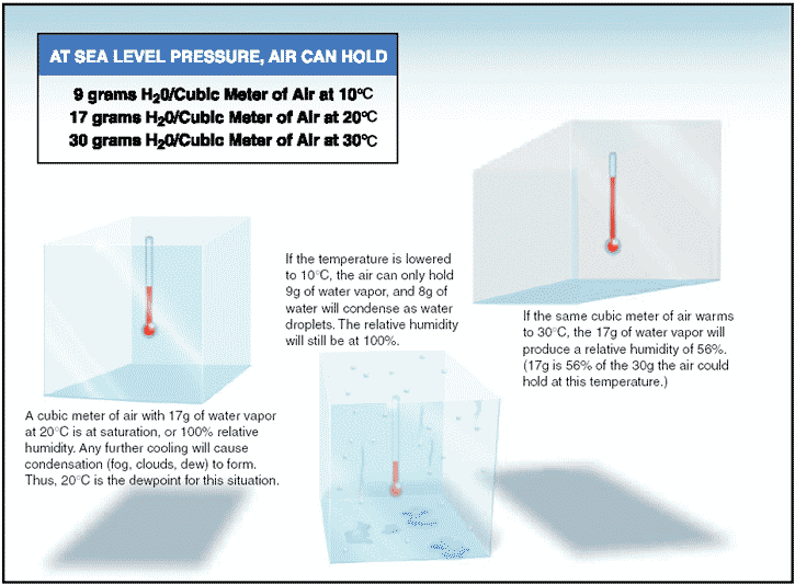
Figure 20: The relationship between relative humidity, temperature, and dewpoint.
Temperature/dewpoint relationship
The relationship between dewpoint and temperature defines the concept of relative humidity. The dewpoint, given in degrees, is the temperature at which the air can hold no more moisture. When the temperature of the air is reduced to the dewpoint, the air is completely saturated and moisture begins to condense out of the air in the form of fog, dew, frost, clouds, rain, hail, or snow.
As moist, unstable air rises, clouds often form at the altitude where temperature and dewpoint reach the same value. When lifted, unsaturated air cools at a rate of 5.4°F per 1,000 feet and the dewpoint temperature decreases at a rate of 1°F per 1,000 feet. This results in a convergence of temperature and dewpoint at a rate of 4.4°F. Apply the convergence rate to the reported temperature and dewpoint to determine the height of the cloud base.
Given:
Temperature (T) = 85°F
Dewpoint (DP) = 71°F
Convergence Rate (CR) = 4.4°
T — DP = Temperature Dewpoint Spread (TDS)
TDS÷CR = X
Xx1,000 feet = height of cloud base AGL
Example:
85°F — 71°F = 14°F
14°F÷4.4°F = 3.18
3.18x1,000 = 3,180 feet AGL
The height of the cloud base is 3,180 feet AGL.
Explanation:
With an outside air temperature (OAT) of 85°F at the surface, and dewpoint at the surface of 71°F, the spread is 14°. Divide the temperature dewpoint spread by the convergence rate of 4.4°F, and multiply by 1,000 to determine the approximate height of the cloud base.
Methods by which air reaches the saturation point
If air reaches the saturation point while temperature and dewpoint are close together, it is highly likely that fog, low clouds, and precipitation will form. There are four methods by which air can reach the complete saturation point. First, when warm air moves over a cold surface, the air´s temperature drops and reaches the saturation point. Second, the saturation point may be reached when cold air and warm air mix. Third, when air cools at night through contact with the cooler ground, air reaches its saturation point. The fourth method occurs when air is lifted or is forced upward in the atmosphere.
As air rises, it uses heat energy to expand. As a result, the rising air loses heat rapidly. Unsaturated air loses heat at a rate of 3.0°C (5.4°F) for every 1,000 feet of altitude gain. No matter what causes the air to reach its saturation point, saturated air brings clouds, rain, and other critical weather situations.
Dew and frost
On cool, calm nights, the temperature of the ground and objects on the surface can cause temperatures of the surrounding air to drop below the dewpoint. When this occurs, the moisture in the air condenses and deposits itself on the ground, buildings, and other objects like cars and aircraft. This moisture is known as dew and sometimes can be seen on grass in the morning. If the temperature is below freezing, the moisture will be deposited in the form of frost. While dew poses no threat to an aircraft, frost poses a definite flight safety hazard. Frost disrupts the flow of air over the wing and can drastically reduce the production of lift. It also increases drag, which, when combined with lowered lift production, can eliminate the ability to take off. An aircraft must be thoroughly cleaned and free of frost prior to beginning a flight.
Fog, by definition, is a cloud that begins within 50 feet of the surface. It typically occurs when the temperature of air near the ground is cooled to the air´s dewpoint.
At this point, water vapor in the air condenses and becomes visible in the form of fog. Fog is classified according to the manner in which it forms and is dependent upon the current temperature and the amount of water vapor in the air.
On clear nights, with relatively little to no wind present, radiation fog may develop.
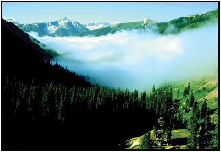
Figure 21: Radiation fog.
Usually, it forms in low-lying areas like mountain valleys. This type of fog occurs when the ground cools rapidly due to terrestrial radiation, and the surrounding air temperature reaches its dewpoint. As the sun rises and the temperature increases, radiation fog will lift and eventually burn off. Any increase in wind will also speed the dissipation of radiation fog. If radiation fog is less than 20 feet thick, it is known as ground fog.
When a layer of warm, moist air moves over a cold surface, advection fog is likely to occur. Unlike radiation fog, wind is required to form advection fog.
Winds of up to 15 knots allow the fog to form and intensify; above a speed of 15 knots, the fog usually lifts and forms low stratus clouds. Advection fog is common in coastal areas where sea breezes can blow the air over cooler landmasses.
In these same coastal areas, upslope fog is likely as well. Upslope fog occurs when moist, stable air is forced up sloping land features like a mountain range.
This type of fog also requires wind for formation and continued existence. Upslope and advection fog, unlike radiation fog, may not burn off with the morning sun, but instead can persist for days. They also can extend to greater heights than radiation fog.
Steam fog, or sea smoke, forms when cold, dry air moves over warm water. As the water evaporates, it rises and resembles smoke. This type of fog is common over bodies of water during the coldest times of the year. Low-level turbulence and icing are commonly associated with steam fog.
Ice fog occurs in cold weather when the temperature is much below freezing and water vapor forms directly into ice crystals. Conditions favorable for its formation are the same as for radiation fog except for cold temperature, usually -25°F or colder. It occurs mostly in the arctic regions, but is not unknown in middle latitudes during the cold season.
Clouds
Clouds are visible indicators and are often indicative of future weather. For clouds to form, there must be adequate water vapor and condensation nuclei, as well as a method by which the air can be cooled. When the air cools and reaches its saturation point, the invisible water vapor changes into a visible state. Through the processes of deposition (also referred to as sublimation) and condensation, moisture condenses or sublimates onto miniscule particles of matter like dust, salt, and smoke known as condensation nuclei. The nuclei are important because they provide a means for the moisture to change from one state to another.
Cloud type is determined by its height, shape, and behavior. They are classified according to the height of their bases as low, middle, or high clouds, as well as clouds with vertical development.
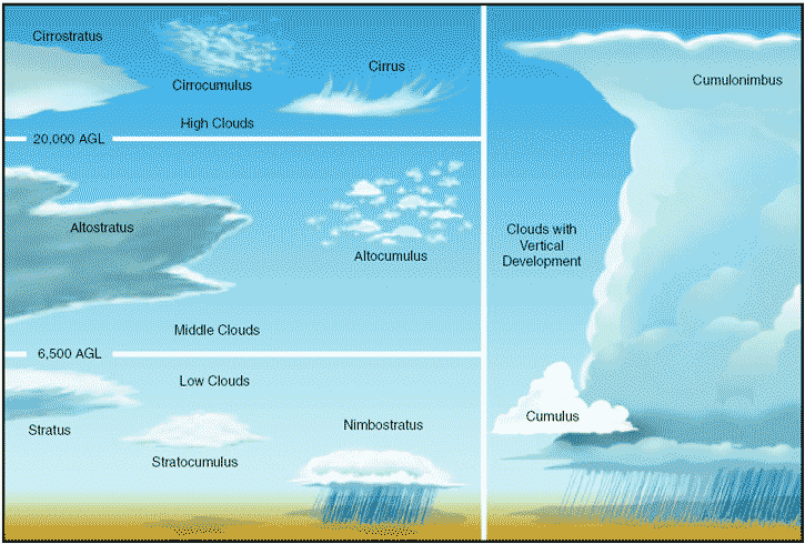
Figure 22: Basic cloud types.
Low clouds are those that form near the Earth´s surface and extend up to 6,500 feet AGL. They are made primarily of water droplets, but can include supercooled water droplets that induce hazardous aircraft icing. Typical low clouds are stratus, stratocumulus, and nimbostratus. Fog is also classified as a type of low cloud formation. Clouds in this family create low ceilings, hamper visibility, and can change rapidly. Because of this, they influence flight planning and can make VFR flight impossible.
Middle clouds form around 6,500 feet AGL and extend up to 20,000 feet AGL. They are composed of water, ice crystals, and supercooled water droplets. Typical middle-level clouds include altostratus and altocumulus. These types of clouds may be encountered on cross-country flights at higher altitudes. Altostratus clouds can produce turbulence and may contain moderate icing. Altocumulus clouds, which usually form when altostratus clouds are breaking apart, also may contain light turbulence and icing.
High clouds form above 20,000 feet AGL and usually form only in stable air. They are made up of ice crystals and pose no real threat of turbulence or aircraft icing.
Typical high-level clouds are cirrus, cirrostratus, and cirrocumulus.
Clouds with extensive vertical development are cumulus clouds that build vertically into towering cumulus or cumulonimbus clouds. The bases of these clouds form in the low to middle cloud base region but can extend into high altitude cloud levels. Towering cumulus clouds indicate areas of instability in the atmosphere, and the air around and inside them is turbulent. These types of clouds often develop into cumulonimbus clouds or thunderstorms.
Cumulonimbus clouds contain large amounts of moisture and unstable air, and usually produce hazardous weather phenomena such as lightning, hail, tornadoes, gusty winds, and wind shear. These extensive vertical clouds can be obscured by other cloud formations and are not always visible from the ground or while in flight. When this happens, these clouds are said to be embedded, hence the term, embedded thunderstorms.
Cloud classification can be further broken down into specific cloud types according to the outward appearance and cloud composition. Knowing these terms can help identify visible clouds.
The following is a list of cloud classifications:
- Cumulus—Heaped or piled clouds.
- Stratus—Formed in layers.
- Cirrus—Ringlets; fibrous clouds; also high-level clouds above 20,000 feet.
- Castellanus—Common base with separate vertical development; castle-like.
- Lenticularus—Lens shaped; formed over mountains in strong winds.
- Nimbus—Rain bearing clouds.
- Fracto—Ragged or broken.
- Alto—Meaning high; also middle-level clouds existing at 5,000 to 20,000 feet.
Figures 23 — 36 give an impression of typical appearances of various forms of clouds.
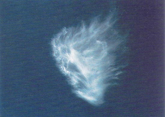
Figure 23: Cirrus
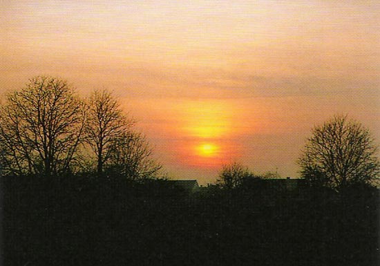
Figure 24: Cirrostratus
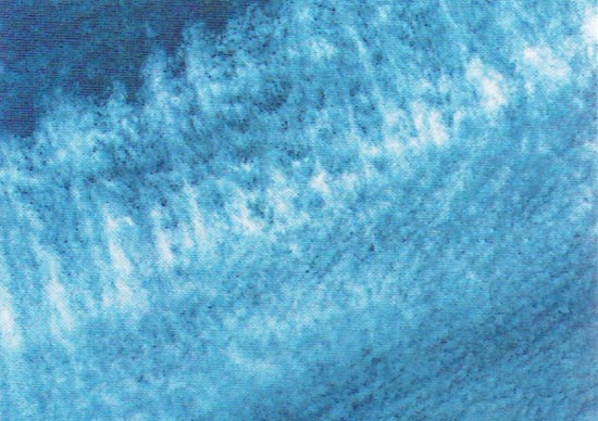
Figure 25: Cirrocumulus

Figure 26: Cumulus humilis

Figure 27: Cumulus mediocris
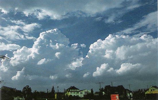
Figure 28: Cumulus congestus

Figure 29: Stratus
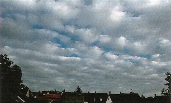
Figure 30: Stratocumulus
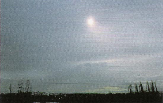
Figure 31: Altostratus

Figure 32: Altocumulus

Figure 33: Altocumulus castellanus
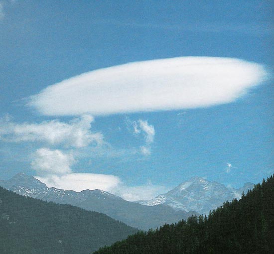
Figure 34: Altocumulus lenticularis
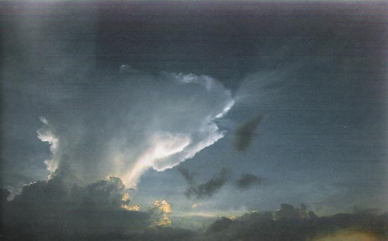
Figure 35: Cumulonimbus

Figure 36: Nimbostratus
To pilots, the cumulonimbus cloud is perhaps the most dangerous cloud type. It appears individually or in groups and is known as either an air mass or orographic thunderstorm. Heating of the air near the Earth´s surface creates an air mass thunderstorm; the upslope motion of air in the mountainous regions causes orographic thunderstorms. Cumulonimbus clouds that form in a continuous line are nonfrontal bands of thunderstorms or squall lines.
Since rising air currents cause cumulonimbus clouds, they are extremely turbulent and pose a significant hazard to flight safety. For example, if an aircraft enters a thunderstorm, the aircraft could experience updrafts and downdrafts that exceed 3,000 feet per minute. In addition, thunderstorms can produce large hailstones, damaging lightning, tornadoes, and large quantities of water, all of which are potentially hazardous to aircraft.
A thunderstorm makes its way through three distinct stages before dissipating. It begins with the cumulus stage, in which lifting action of the air begins. If sufficient moisture and instability are present, the clouds continue to increase in vertical height.
Continuous, strong updrafts prohibit moisture from falling. The updraft region grows larger than the individual thermals feeding the storm. Within approximately 15 minutes, the thunderstorm reaches the mature stage, which is the most violent time period of the thunderstorm´s life cycle. At this point, drops of moisture, whether rain or ice, are too heavy for the cloud to support and begin falling in the form of rain or hail. This creates a downward motion of the air. Warm, rising air; cool, precipitation-induced descending air; and violent turbulence all exist within and near the cloud. Below the cloud, the down-rushing air increases surface winds and decreases the temperature. Once the vertical motion near the top of the cloud slows down, the top of the cloud spreads out and takes on an anvil-like shape. At this point, the storm enters the dissipating stage. This is when the downdrafts spread out and replace the updrafts needed to sustain the storm.
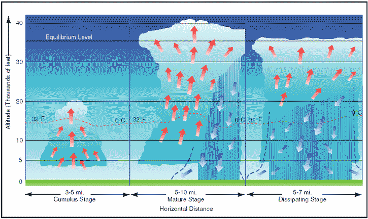
Figure 37: Life cycle of a thunderstorm.
It is impossible to fly over thunderstorms in light aircraft. Severe thunderstorms can punch through the tropopause and reach staggering heights of 50,000 to 60,000 feet depending on latitude. Flying under thunderstorms can subject aircraft to rain, hail, damaging lightning, and violent turbulence. A good rule of thumb is to circumnavigate thunderstorms by at least 5 nautical miles (NM) since hail may fall for miles outside of the clouds. If flying around a thunderstorm is not an option, stay on the ground until it passes.
Ceiling
A ceiling, for aviation purposes, is the lowest layer of clouds reported as being broken or overcast, or the vertical visibility into an obscuration like fog or haze.
Clouds are reported as broken when five-eighths to seven-eighths of the sky is covered with clouds.
Overcast means the entire sky is covered with clouds.
Current ceiling information is reported by the aviation routine weather report (METAR) and automated weather stations of various types.
Visibility
Closely related to cloud cover and reported ceilings is visibility information. Visibility refers to the greatest horizontal distance at which prominent objects can be viewed with the naked eye. Current visibility is also reported in METAR and other aviation weather reports, as well as automated weather stations. Visibility information, as predicted by meteorologists, is available during a preflight weather briefing.
Precipitation
Precipitation refers to any form of water particles that form in the atmosphere and fall to the ground. It has a profound impact on flight safety. Depending on the form of precipitation, it can reduce visibility, create icing situations, and affect landing and takeoff performance of an aircraft.
Precipitation occurs because water or ice particles in clouds grow in size until the atmosphere can no longer support them. It can occur in several forms as it falls toward the Earth, including drizzle, rain, ice pellets, hail, and ice.
Drizzle is classified as very small water droplets, smaller than 0.02 inches in diameter. Drizzle usually accompanies fog or low stratus clouds. Water droplets of larger size are referred to as rain. Rain that falls through the atmosphere but evaporates prior to striking the ground is known as virga. Freezing rain and freezing drizzle occur when the temperature of the surface is below freezing; the rain freezes on contact with the cooler surface.
If rain falls through a temperature inversion, it may freeze as it passes through the underlying cold air and fall to the ground in the form of ice pellets. Ice pellets are an indication of a temperature inversion and that freezing rain exists at a higher altitude. In the case of hail, freezing water droplets are carried up and down by drafts inside clouds, growing larger in size as they come in contact with more moisture. Once the updrafts can no longer hold the freezing water, it falls to the Earth in the form of hail. Hail can be pea-sized, or it can grow as large as 5 inches in diameter, larger than a softball.
Snow is precipitation in the form of ice crystals that falls at a steady rate or in snow showers that begin, change in intensity, and end rapidly. Falling snow also varies in size, being very small grains or large flakes.
Snow grains are the equivalent of drizzle in size.
Precipitation in any form poses a threat to safety of flight. Often, precipitation is accompanied by low ceilings and reduced visibility. Aircraft that have ice, snow, or frost on their surfaces must be carefully cleaned prior to beginning a flight because of the possible airflow disruption and loss of lift. Rain can contribute to water in the fuel tanks. Precipitation can create hazards on the runway surface itself, making takeoffs and landings difficult, if not impossible, due to snow, ice, or pooling water and very slick surfaces.
Air masses
Air masses are large bodies of air that take on the characteristics of the surrounding area, or source region. A source region is typically an area in which the air remains relatively stagnant for a period of days or longer. During this time of stagnation, the air mass takes on the temperature and moisture characteristics of the source region. Areas of stagnation can be found in polar regions, tropical oceans, and dry deserts. Air masses are classified based on their region of origination:
- Polar or Tropical
- Maritime or Continental
A continental polar air mass forms over a polar region and brings cool, dry air with it. Maritime tropical air masses form over warm tropical waters like the Caribbean Sea and bring warm, moist air. As the air mass moves from its source region and passes over land or water, the air mass is subjected to the varying conditions of the land or water, and these modify the nature of the air mass.
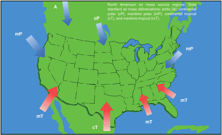
Figure 38: Air mass source regions.
An air mass passing over a warmer surface will be warmed from below, and convective currents form, causing the air to rise. This creates an unstable air mass with good surface visibility. Moist, unstable air causes cumulus clouds, showers, and turbulence to form.
Conversely, an air mass passing over a colder surface does not form convective currents, but instead creates a stable air mass with poor surface visibility. The poor surface visibility is due to the fact that smoke, dust, and other particles cannot rise out of the air mass and are instead trapped near the surface. A stable air mass can produce low stratus clouds and fog.
Fronts
As air masses move across bodies of water and land, they eventually come in contact with another air mass with different characteristics. The boundary layer between two types of air masses is known as a front.
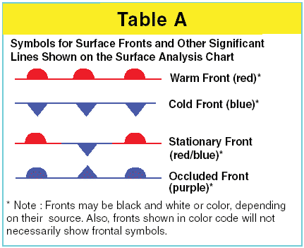
Figure 39: Common chart symbology to depict weather front location.
An approaching front of any type always means changes to the aviation weather are imminent.
There are four types of fronts, which are named according to the temperature of the advancing air as it relates to the temperature of the air it is replacing.
- Warm Front
- Cold Front
- Stationary Front
- Occluded Front
Any discussion of frontal systems must be tempered with the knowledge that no two fronts are the same.
However, generalized weather conditions are associated with a specific type of front that helps identify the front.
Warm front
A warm front occurs when a warm mass of air advances and replaces a body of colder air. Warm fronts move slowly, typically 10 to 25 miles per hour (m.p.h.).
The slope of the advancing front slides over the top of the cooler air and gradually pushes it out of the area.
Warm fronts contain warm air that often has very high humidity. As the warm air is lifted, the temperature drops and condensation occurs.
Generally, prior to the passage of a warm front, cirriform or stratiform clouds, along with fog, can be expected to form along the frontal boundary. In the summer months, cumulonimbus clouds (thunderstorms) are likely to develop. Light to moderate precipitation is probable, usually in the form of rain, sleet, snow, or drizzle, punctuated by poor visibility. The wind blows from the south-southeast, and the outside temperature is cool or cold, with increasing dew point. Finally, as the warm front approaches, the barometric pressure continues to fall until the front passes completely.
During the passage of a warm front, stratiform clouds are visible and drizzle may be falling. The visibility is generally poor, but improves with variable winds. The temperature rises steadily from the inflow of relatively warmer air. For the most part, the dew point remains steady and the pressure levels off.
After the passage of a warm front, stratocumulus clouds predominate and rain showers are possible. The visibility eventually improves, but hazy conditions may exist for a short period after passage. The wind blows from the south-southwest. With warming temperatures, the dew point rises and then levels off. There is generally a slight rise in barometric pressure, followed by a decrease of barometric pressure.
Flight toward an approaching warm front
By studying a typical warm front, much can be learned about the general patterns and atmospheric conditions that exist when a warm front is encountered in flight.
Figure 40 depicts a warm front advancing eastward from St. Louis, Missouri, toward Pittsburgh, Pennsylvania.
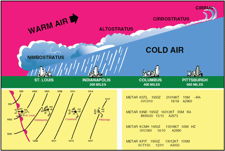
Figure 40: Warm front cross-section with surface weather chart depiction and associated METAR.
At the time of departure from Pittsburgh, the aviation weather is good VFR with a scattered layer of cirrus clouds at 15,000 feet. As the flight progresses westward to Columbus and closer to the oncoming warm front, the clouds deepen and become increasingly stratiform in appearance with a ceiling of 6,000 feet. The visibility decreases to 6 miles in haze with a falling barometric pressure. Approaching Indianapolis, the aviation weather deteriorates to broken clouds at 2,000 feet with 3 miles visibility and rain. With the temperature and dew point the same, fog is likely. At St. Louis, the sky is overcast with low clouds and drizzle and the visibility is 1 mile.
Beyond Indianapolis, the ceiling and visibility would be too low to continue VFR. Therefore, it would be wise to remain in Indianapolis until the warm front had passed, which might require a day or two.
Cold front
A cold front occurs when a mass of cold, dense, and stable air advances and replaces a body of warmer air.
Cold fronts move more rapidly than warm fronts, progressing at a rate of 25 to 30 m.p.h. However, extreme cold fronts have been recorded moving at speeds of up to 60 m.p.h. A typical cold front moves in a manner opposite that of a warm front; because it is so dense, it stays close to the ground and acts like a snowplow, sliding under the warmer air and forcing the less dense air aloft. The rapidly ascending air causes the temperature to decrease suddenly, forcing the creation of clouds. The type of clouds that form depends on the stability of the warmer air mass. A cold front in the Northern Hemisphere is normally oriented in a northeast to southwest manner and can be several hundred miles long, encompassing a large area of land.
Prior to the passage of a typical cold front, cirriform or towering cumulus clouds are present, and cumulonimbus clouds are possible. Rain showers and haze are possible due to the rapid development of clouds. The wind from the south-southwest helps to replace the warm temperatures with the relative colder air. A high dew point and falling barometric pressure are indicative of imminent cold front passage.
As the cold front passes, towering cumulus or cumulonimbus clouds continue to dominate the sky.
Depending on the intensity of the cold front, heavy rain showers form and might be accompanied by lightning, thunder, and/or hail. More severe cold fronts can also produce tornadoes. During cold front passage, the visibility will be poor, with winds variable and gusty, and the temperature and dew point drop rapidly. A quickly falling barometric pressure bottoms out during frontal passage, then begins a gradual increase.
After frontal passage, the towering cumulus and cumulonimbus clouds begin to dissipate to cumulus clouds with a corresponding decrease in the precipitation. Good visibility eventually prevails with the winds from the west-northwest. Temperatures remain cooler and the barometric pressure continues to rise.
Fast-moving cold front
Fast-moving cold fronts are pushed by intense pressure systems far behind the actual front. The friction between the ground and the cold front retards the movement of the front and creates a steeper frontal surface. This results in a very narrow band of weather, concentrated along the leading edge of the front. If the warm air being overtaken by the cold front is relatively stable, overcast skies and rain may occur for some distance ahead of the front. If the warm air is unstable, scattered thunderstorms and rain showers may form. A continuous line of thunderstorms, or a squall line, may form along or ahead of the front. Squall lines present a serious hazard to pilots as squall type thunderstorms are intense and move quickly. Behind a fast moving cold front, the skies usually clear rapidly and the front leaves behind gusty, turbulent winds and colder temperatures.
Flight toward an approaching cold front
Like warm fronts, not all cold fronts are the same. Examining a flight toward an approaching cold front, pilots can get a better understanding of the type of conditions that can be encountered in flight. Figure 41 shows a flight from Pittsburgh, Pennsylvania, toward St. Louis, Missouri.
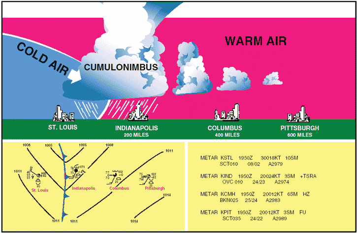
Figure 41: Cold front cross-section with surface weather chart depiction and associated METAR.
At the time of departure from Pittsburgh, the aviation weather is VFR with 3 miles visibility in smoke and a scattered layer of clouds at 3,500 feet. As the flight progresses westward to Columbus and closer to the oncoming cold front, the clouds show signs of vertical development with a broken layer at 2,500 feet. The visibility is 6 miles in haze with a falling barometric pressure.
Approaching Indianapolis, the aviation weather has deteriorated to overcast clouds at 1,000 feet, and 3 miles visibility with thunderstorms and heavy rain showers. At St. Louis, the aviation weather gets better with scattered clouds at 1,000 feet and a 10 mile visibility.
A pilot using sound judgment based on the knowledge of frontal conditions, would most likely remain in Indianapolis until the front had passed. Trying to fly below a line of thunderstorms or a squall line is hazardous and foolish, and flight over the top of or around the storm is not an option. Thunderstorms can extend up to well over the capability of small airplanes and can extend in a line for 300 to 500 miles.
Comparison of cold and warm fronts
Warm fronts and cold fronts are very different in nature as are the hazards associated with each front. They vary in speed, composition, weather phenomenon, and prediction. Cold fronts, which move at 20 to 35 m.p.h., move very quickly in comparison to warm fronts, which move at only 10 to 25 m.p.h. Cold fronts also possess a steeper frontal slope. Violent weather activity is associated with cold fronts and the weather usually occurs along the frontal boundary, not in advance.
However, squall lines can form during the summer months as far as 200 miles in advance of a severe cold front. Whereas warm fronts bring low ceilings, poor visibility, and rain, cold fronts bring sudden storms, gusty winds, turbulence, and sometimes hail or tornadoes.
Cold fronts are fast approaching with little or no warning, and they make a complete aviation weather change in just a few hours. The weather clears rapidly after passage and drier air with unlimited visibilities prevail.
Warm fronts, on the other hand, provide advance warning of their approach and can take days to pass through a region.
Wind shifts
Wind around a high-pressure system rotates in a clockwise fashion, while low-pressure winds rotate in a counter-clockwise manner. When two high-pressure systems are adjacent, the winds are almost in direct opposition to each other at the point of contact. Fronts are the boundaries between two areas of pressure, and therefore, wind shifts are continually occurring within a front. Shifting wind direction is most pronounced in conjunction with cold fronts.
Stationary front
When the forces of two air masses are relatively equal, the boundary or front that separates them remains stationary and influences the local aviation weather for days.
This front is called a stationary front. The aviation weather associated with a stationary front is typically a mixture that can be found in both warm and cold fronts.
Occluded front
An occluded front occurs when a fast-moving cold front catches up with a slow-moving warm front. As the occluded front approaches, warm front weather prevails, but is immediately followed by cold front weather. There are two types of occluded fronts that can occur, and the temperatures of the colliding frontal systems play a large part in defining the type of front and the resulting aviation weather. A cold front occlusion occurs when a fast-moving cold front is colder than the air ahead of the slow-moving warm front. When this occurs, the cold air replaces the cool air and forces the warm front aloft into the atmosphere. Typically, the cold front occlusion creates a mixture of weather found in both warm and cold fronts, providing the air is relatively stable. A warm front occlusion occurs when the air ahead of the warm front is colder than the air of the cold front. When this is the case, the cold front rides up and over the warm front. If the air forced aloft by the warm front occlusion is unstable, the weather will be more severe than the weather found in a cold front occlusion. Embedded thunderstorms, rain, and fog are likely to occur.
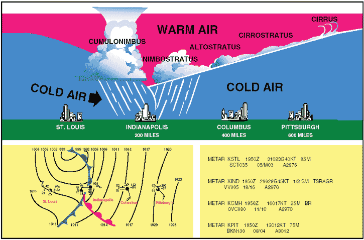
Figure 42: Occluded front cross-section with a weather chart depiction and associated METAR.
Figure 42 depicts a cross-section of a typical cold front occlusion. The warm front slopes over the prevailing cooler air and produces the warm front type weather. Prior to the passage of the typical occluded front, cirriform and stratiform clouds prevail, light to heavy precipitation is falling, visibility is poor, dew point is steady, and barometric pressure is falling. During the passage of the front, nimbostratus and cumulonimbus clouds predominate, and towering cumulus may also be possible. Light to heavy precipitation is falling, visibility is poor, winds are variable, and the barometric pressure is leveling off.
After the passage of the front, nimbostratus and altostratus clouds are visible, precipitation is decreasing and clearing, and visibility is improving.